 EN
EN Español
Other nature trails
The exceptional beauty of the municipal area of Pinilla del Valle and the surrounding valley invite you to be in contact with nature by making routes. Walking is a very healthy exercise and more when done in the monutains, where you can breathe fresh air and live unforgettable sensations.
The following routes that we describe are completely signposted and equipped. However if you require more information or information about the possibility of conducting them with guidance do not hesitate to contact the city.
ROUTE 1. FOREST ROADS
In a mountain village it was necessary to go to the mountain by the old offices and by the cattle. That is why there are, in mountains and clearings, a watermark of paths and paths, some of them of great scenic beauty. In addition, mountains such as "Cancho Cagao", "Espartal" or "Nevero" peak are summits desired by hikers and vacationers.
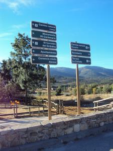
With a map of the territory in hand or with the indications of neighbors or staff of the town hall you can discover the viewpoints from where it is easy to interpret the mountain landscape, the town and the great reservoir of Pinilla; And to see hills, sheepfolds, streams and rocks. In some places such as "Dehesa Boyal", Roblemoreno or in Mirador del Pinar, there are panels to familiarize us with the toponymy of the Lozoya high valley, names that fascinate us by its originality or by its phonetics in the intonations of the locals.
Through these fully signposted and equipped roads, you can access our mountains, on whose summits there are explanatory panels that look like a viewpoint, where the landscape can be explained graphically.
ROUTE 2. AROUND THE RESERVOIR
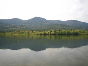 There is the Pinilla reservoir two urbanized settlements on its banks: Lozoya and Pinilla, which gives it its name. It is therefore a referent for its residents.
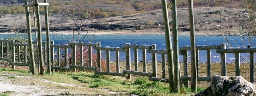
In the village, next to the reservoir, there is a viewpoint and a walk conditioned with benches and an ingenious signpost from where to familiarize itself with the names of the peaks that surround it. Two restaurants, La Cañada and El Corralón del Embalse, for their situation invite visitors to look at the beauty of this mountainous and aquatic landscape.
Around the reservoir there are places of importance such as Calvero de la Higuera, where the paleontological site or Puente Nuevo from where you can see Peñalara mountain and the vegetation of the banks of the river Lozoya.
The swamp is a piece of this village of old tile roofs with its centenary church. A gift lake that has to take care of the same as this hacienda of mountains, meadows, forests, streets, children and adults. A living place that values itself and measures itself.
This route starts from the confluence of Pinilla del Valle with the reservoir in the direction of Alameda and later crossing the reservoir through a bridge until arriving at the restaurant La Cañada from where it leaves the road, first in the direction of the Archaeological Site and later to Lozoya. This route is totally accessible for all walkers.
ROUTE 3. NATURAL WAY IN THE PINILLA TRAIL
This commitment to rural tourism in the commonwealth of Lozoya Valley is an invitation to get back on track; Action somewhat against these times of traffic.
 Take advantage of the roads that joined the villages of the valley from El Cuadrón to Rascafría. Roads that had been forgotten and were difficult to take by the obstacles that came with the water and the ice.
As soon as they cross the iron heath that borders Lozoya and Pinilla, the ash trees that flank the road join their higher branches, almost forming a pergola of leaves, and have the blackberries embracing their trunks.
Towards Pinilla, these brambles and other thorns, like the wild rose bush, reach their wide solos or around the centuries-old ash trees that are sometimes ambushed in long rows of logs of the same height. We are in the Dehesa Boyal.
To follow the Natural Way you have to cross the pasture and the village towards the west. By the road recoleto of the left can be done bordering the town by the reservoir. One meets one with a place enabled to do gymnastics outdoors. Then you can enjoy, by the edge of the marsh, low houses and haystacks and the restaurant El Corralón del Embalse. It is a beautiful area to walk where there are benches and an ingenious signpost on a rock. It is possible, turning a metal arrow, to know the location and the name of the mountain peaks and other places.
At the end of this walk, you reach the section of the Natural Way that connects Pinilla with Alameda del Valle. This part is known by the name of the path of the Charcas.
More information about Camino Natural del Valle (Spanish)